
Jefferson Neighbors by Block Source
Public sources describe different parts of a Jefferson block. The county parcel layer maps the parcel shape and identifies owner and address attributes. JCAD supplies property, situs, mailing-address, and legal-description details for an individual parcel. County Clerk documents can show a plat, lot and block, deed, easement, or shared subdivision. Beaumont’s community list provides a voluntary association’s public meeting or contact channel. None of those sources is a complete list of every person at every nearby address.
| Source | What It Shows About a Block | Access |
|---|---|---|
| Jefferson County GIS parcel layer | Adjacent polygons, owner and address attributes, parcel IDs, and street geometry | Public viewer; click, zoom, and identify, then verify in JCAD |
| JCAD property search | Owner, situs, mailing address, legal description, value, and exemptions for a parcel | Public property portal |
| County Clerk deeds and plats | Lot, block, shared subdivision, easement, and recorded transaction details | Official records search, counter, or historical repositories |
| Texas voter route | Lawfully released registration, status, precinct, and address fields | Individual tool or statutory file request, not a casual block export |
| Beaumont neighborhood associations | Voluntary community boundary, meeting, and public contact channel | City association listing |
| Directories and newspapers | Historical occupants, organizations, businesses, and address changes | Tyrrell library collections and microfilm |
Property ownership and current occupancy are separate facts. A mailing address can be outside Jefferson County, and a legal owner may not be the person currently using the property. Record the parcel number and map access date beside each Jefferson block note. That makes the block observation repeatable when a county layer changes.
Jefferson Neighbor Parcel Records
The Jefferson County GIS parcel viewer is the map step, not the final record. Its parcel service identifies a feature polygon and owner or address attributes, with OWNERNAME described as the display field. The parcel layer is generated nightly. Zoom to the target street segment, use the identify function on the target parcel, and note the parcel or geographic identifier. Then run that identifier or the address through JCAD before drawing a conclusion about Jefferson neighbors.
| Viewer Element | Jefferson Block Use |
|---|---|
| Parcel boundary | Shows the feature polygon to compare with the target address and nearby parcels. |
| Owner and address attributes | Provides an identification lead that should be checked against JCAD. |
| Zoom and pan | Lets a reader inspect the street segment and polygons immediately around it. |
| Selection or query service | The public service supports query and selection, but exact live control labels require viewer confirmation. |
| Beaumont map layers | Permit, code, zoning, floodplain, and utility layers add context but are not official records. |
Do not infer that two shapes touch solely because they look close on a screen. The service metadata supports selection and query, but the research did not verify an exact public buffer or radius button. If the viewer presents an identify, select, or buffer control during a live check, record the method used. When lines are uncertain, a recorded plat is stronger evidence than a visual estimate.
Mapping Jefferson Neighbors Through Parcels
Use a short chain from one address outward. The process is designed to identify parcels around a Jefferson address without claiming that a parcel record names every household member. The target’s legal description is the bridge between the map and the Clerk’s records.
- Search the target address in JCAD and record its parcel or geographic ID, situs, mailing address, subdivision, and legal description.
- Open the county GIS viewer, locate the same parcel, and zoom until the street segment and adjoining polygons are clear.
- Click each parcel sharing a boundary or directly across the street. Record the displayed owner or address attribute and its parcel ID.
- Confirm each parcel through JCAD. If the block edge matters, inspect the recorded plat and County Clerk documents for lot, block, or easement details.
This flow is address to parcel, parcel to adjoining parcel, then parcel to official record. For a full named-street chain rather than the immediate block, use the Jefferson street directory route, which follows address-keyed records farther along a street.
Jefferson Block Parcel Records
A Jefferson plat or deed can resolve a boundary question that a map preview cannot. Search the County Clerk’s Official Records Search by current owner, prior owner, subdivision, document type, or document number. The portal’s Quick and Advanced search modes also allow a recorded-date range and either index-only or index-and-OCR searching. OCR treats two or more words as a phrase, while index-only searching uses indexed information. The portal does not state its earliest online year, so older block research may need the Clerk counter, Tyrrell Historical Library, or Sam Houston Center microfilm.
Lot and block language matters because postal labels, neighborhood labels, and city lines do not always follow one another. A Beaumont map hub also warns that its interactive maps are general information rather than official maps. When a permit or code item affects a Jefferson block question, use the map only to identify the location or case, then ask Beaumont Code Enforcement or the City Clerk for the official file.
- Parcel
- A mapped unit of land used by the appraisal and GIS systems. Its map shape is a starting point for a boundary check.
- Plat
- A recorded map of a subdivision or lot layout. It can clarify whether parcels touch or share a street edge.
- Legal description
- The lot, block, abstract, or other land description in a deed or plat. It lasts longer than a casual street-label change.
Jefferson Neighbor Association Channels
Beaumont’s neighborhood-association page offers a community layer for a Jefferson block, not a private roster. The city says associations are independent and are not officially approved, sanctioned, or managed by Beaumont. They are voluntary groups and do not have city-granted authority to impose fees or restrictions. Meeting places can sit outside the named neighborhood, and active or inactive status may change. Use a public contact or meeting to ask about shared concerns, history, and local resources, not to infer membership.
Acorn
First Monday, 6 p.m.
Forest Park Methodist Church
Doug Landry: 781-5296
CANA
First Thursday, 6:30 p.m.
First Christian Church
Tami Rhodes-Hathaway: 409-926-3369
North End
Fourth Monday, 6:30 p.m.
John Paul Davis Community Center
Katherine Campbell: 409-835-0721
Pear Orchard
Fourth Thursday, 6:30 p.m.
Theodore Johns Library
Delilah Johnson: 409-338-3712
The Beaumont neighborhood-association listing is shown below as a Jefferson block follow-up for current public contacts and meeting information.
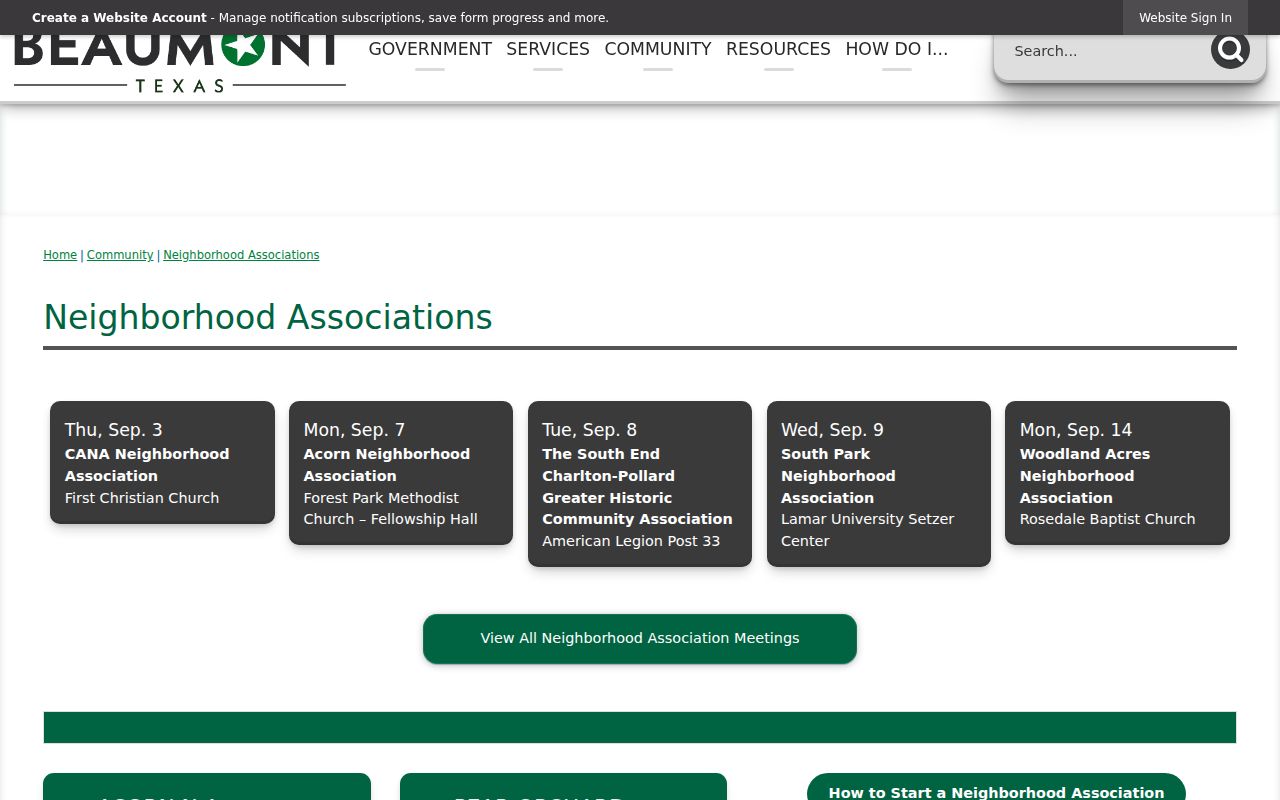
Recheck the city listing before relying on a meeting time, contact, or active-status label because the page treats these details as current community information.
Jefferson Neighbors at The Oaks
The Oaks Historic District is a useful local distinction for Jefferson block research. It is a historic neighborhood with a voluntary neighborhood association, not a city-managed HOA. The association describes boundaries as Beech Street to the north, Rusk Street to the south, First Street to the east, and Eleventh Street to the west. Its public materials describe a small annual fee and quarterly meetings at the McFaddin-Ward House Visitor Center. Those statements explain community context, but they do not establish who belongs to the association or who lives at a particular parcel.
For older block questions, pair a legal description with dated maps. The 1902 Beaumont landownership map and the 1911 Beaumont Sanborn collection can explain a lot, street, or building context. Neither is a household list. The map record is most useful when a present-day Jefferson parcel needs a historic location check before a directory, deed, or newspaper search.
Port Arthur Neighbors Through Action Groups
Jefferson County includes more than Beaumont, so community context can shift across the block. Port Arthur’s Community Relations page identifies Neighborhood Action Groups and Concerned Citizens groups for Pear Ridge, Park Place, Lakeview, West Side, Montrose, Port Acres, Sabine Pass, Griffing Park, Lakeside, and other named areas. The city says any resident may join and reports more than 1,000 participants. Its public contact number is 409-984-8559 at 444 4th Street in Port Arthur.
These groups are a way to ask a public community question or locate a meeting channel. They are not a directory of nearby people. A Port Arthur postal label, association boundary, and parcel jurisdiction can differ, so check the parcel’s taxing-unit and city or county context before assuming that one label answers every location question.
Jefferson Neighbors and Voter Records
Texas voter records have a separate legal route. The ordinary Secretary of State tool is for confirming a known individual’s registration and polling information. It is not a browser for every name around a Jefferson block. A public voter-file request under Form 24-1 can include permanent house number and street, city, ZIP, mailing address, precinct, VUID, registration status, effective date, and participation fields. The request requires a notarized affidavit, a $75 deposit, and full payment before release.
Protected addresses, Social Security numbers, Texas driver-license or ID numbers, full dates of birth, and Address Confidentiality Program information are not ordinary public display. A voter address is a record field with an applicable status or date, not a claim about every person who lives there. Texas Election Code §18.067 also restricts using the file to advertise or promote commercial products or services.
Note: Preserve the voter-file status code and access date because an address or registration status can change after the file is released.
Official Records Versus Neighbor Tools
Official Jefferson records and commercial neighbor tools serve different purposes. A county parcel or recorded plat points to a named custodian, document, and date. A commercial tool may combine filings and other information into a paid profile, but a same-name merge, stale address, or missing source can make it unreliable. When a question concerns a block, begin with the official parcel and document chain, then use a public association channel only for community context.
| Official Jefferson Record | Commercial Neighbor Tool Category |
|---|---|
| Identifies a custodian, document, parcel, or access date. | May combine information from multiple sources into one profile. |
| Supports a repeatable parcel or plat check. | Can be stale, incomplete, or merged across same-name people. |
| Has a counter, request, or correction path. | May require a separate opt-out or correction request. |
Use the direct County Clerk, JCAD, GIS, or city contact whenever an address result needs confirmation. It is the only way to test the source record rather than repeating an unverified summary.
Jefferson Neighbor Privacy Limits
Information about Jefferson neighbors cannot expose every household member, utility customer, delivery recipient, or protected resident. DMV residence information is restricted by the Driver’s Privacy Protection Act. Utility and delivery data are not ordinary public resident records. The Texas Address Confidentiality Program can provide a substitute post-office box and forwarding for eligible victims and household members. Protected voter categories can also remove an address from ordinary public display.
Keep the block inquiry focused on lawful personal, civic, family-history, or property-curiosity purposes. If a map or association page conflicts with a recorded plat or legal parcel description, the recorded property evidence carries more weight. A city map label or public meeting notice should never be treated as proof that a person is connected to an address.
Lawful use. Jefferson block information is for personal, lawful research and community context. Do not use a name, address, map, or public contact to stalk, harass, intimidate, or harm anyone.