
Trace a Jefferson Street by Address
Address research in Jefferson County works best as a chain, not a single name search. Begin with the physical parcel, because the Jefferson County Appraisal District can connect a situs address to its owner, mailing address, identifiers, and legal description. A map can then place that parcel among the surrounding lots. The County Clerk records the transactions that explain changes in ownership, while voter and library sources cover different, limited parts of the resident question. An owner, a tax mailing recipient, and a person once listed at an address are not interchangeable. Keeping each record in its proper role makes a street-by-street search more reliable.
- Search the address in the Jefferson County Appraisal District Property Search. If a full address fails, use the street-name approach stated by JCAD and collect the property or geographic ID, situs, mailing address, subdivision, tax year, and legal description.
- Open the Jefferson County GIS viewer, zoom to the parcel, and use its identify result as a map lead. Note the parcel and owner fields, then verify them in JCAD.
- Search the current owner as grantor and grantee in the Jefferson County Clerk Official Records Search. Compare the recorded date, document number, parties, and legal description with the parcel record.
- For a known person, use the official Texas voter-registration route only to confirm an individual registration or polling-place result. A general address search does not supply a casual street roster.
- For an older address question, use Tyrrell Historical Library’s deed index, directories, newspapers, and maps. A historical address entry can identify an occupant at that date, not a current household.
Note: Save the access date and each parcel identifier, since a map view and an appraisal record can change after a transfer.
Jefferson Street Directory Coverage
Jefferson County keeps address-keyed material in several offices. The appraisal and tax systems describe parcels and accounts. The Clerk preserves deeds, plats, liens, and other recorded documents. County GIS supplies the spatial view, and Beaumont adds municipal map layers for permits and code activity. Each source has a different time frame and purpose. A deed can establish a recorded transaction, for example, but it does not establish every person who may be present at an address. The table separates the useful layers before a Jefferson address search turns into guesswork.
| Jefferson address layer | Custodian | Record value | Access route |
|---|---|---|---|
| Appraisal parcel | Jefferson CAD | Owner, situs and mailing address, IDs, legal description, value, exemption, and tax-year fields | JCAD search, then JCAD counter, phone, or request for disputed or older fields |
| Tax account | Jefferson County Tax Office | Owner, account, address, CAD reference, fiduciary, and statement data | Tax Office account search, office, or public-information request |
| Parcel map | Jefferson County GIS | Parcel shape, street geometry, and owner or address attributes | Public viewer, then JCAD for authoritative parcel details |
| Deed, lien, or plat | Jefferson County Clerk | Parties, recording date, document number, and lot, block, or legal description | Official records portal, copy or counter route, Tyrrell, or Sam Houston microfilm |
| Permit or code case | City of Beaumont | Work location, category, status, permit, or inspection lead | Public map, City Works route, Code Enforcement, City Clerk, or public-information request |
| Historical directory | Tyrrell Historical Library | Dated address, occupant, phone, spouse, occupation, and sometimes business notation | Library shelf, microfilm, digital source, or staff research service |
The stable bridge among Jefferson records is often the legal description. A street label can be abbreviated, formatted differently, or tied to a mailing address outside the county. Lot, block, subdivision, abstract, and parcel identifiers make it possible to compare a JCAD result with a Clerk index entry and a plat. The record trail also has fallbacks: the Clerk counter and deed books, Tyrrell’s Jefferson County Index to Deeds for 1836 through 1946, and Sam Houston Regional Library and Research Center microfilm for deed records from 1834 through 1887.
JCAD Fields for a Jefferson Street
The JCAD form is the front end of the modern parcel trail. Its owner option accepts a last-name-first-name format, but JCAD advises trying a first or last name alone when a full name fails. For an address, enter the street number and the street name separately. The portal tells users to omit prefix, suffix, and unit information from the street-name field. That small Jefferson-specific instruction is useful when a fully formatted address returns no result. Search results should be read as appraisal data, not a complete list of people at the site.
| JCAD field or selector | How it helps an address search |
|---|---|
| Owner Name | Search a party by last name first, then use a partial name if the full form does not resolve. |
| Street Number and Street Name | Find a parcel by situs address; use the simple street name without prefix, suffix, or unit when formatting is the problem. |
| Property ID and Geographic ID | Preserve the record key for comparison with a map identify result or tax account. |
| Subdivision, neighborhood, condo, and abstract | Narrow a Jefferson search when an address has changed form or a street name is broad. |
| Tax year, property type, and ARB dates | Place the appraisal result in the right time period and avoid treating a current screen as an undated fact. |
JCAD distinguishes the situs address from the mailing address. Situs means the location of the parcel or building. A mailing address is where appraisal or tax notices go, and it can belong to an owner, agent, or entity elsewhere. The owner record may lag a transfer or omit another household member. Jefferson County parcel fields are therefore strong for identifying a property connection, but they are not proof that a particular person presently occupies the address.
Jefferson GIS Parcels by Street
The county GIS layer is the spatial step between a street name and a record number. Jefferson County GIS materials identify a parcel layer with owner and address attributes and an OWNERNAME display field. The service is generated nightly, so record the date when you view it. Zoom to the street segment, click the target polygon, and copy the parcel or owner information into a research note. Then check it against JCAD or the Clerk before relying on it. When nearby lot lines are uncertain, a recorded plat and legal description are stronger evidence than how two shapes look on a screen.
The City of Beaumont Interactive Maps hub shows the city’s available public map topics, including permits, code enforcement, zoning, floodplain, utilities, and environmental inspection layers.
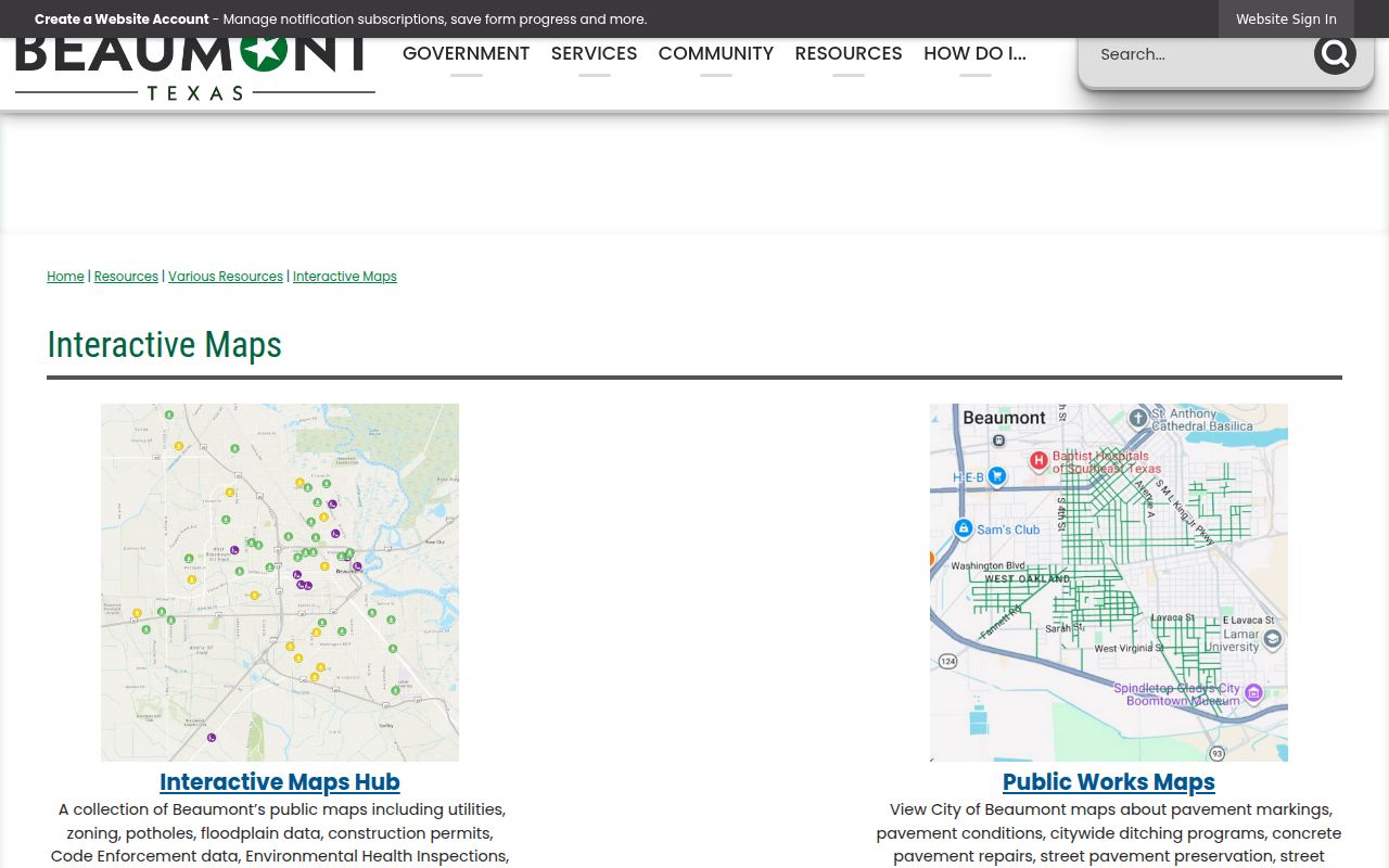
A Jefferson map hit is a useful lead for an address or case identifier. Beaumont cautions that its public maps are general-information maps, so an official copy or record request is the next step when the underlying file matters.
Jefferson Deed Search by Address
The County Clerk’s Official Records Search supplies the recorded-document part of a Jefferson address trail. Its Quick Search and Advanced Search tabs accept a search term for grantor, grantee, subdivision, document type, or document number, plus a recorded-date range. The page also offers Index Only and Index & Full Text (OCR) modes. In index-only mode, two words are searched individually; in OCR, two or more words are treated as a phrase. Start with the parcel owner and legal description, then use the date and subdivision to narrow the result set.
The Jefferson County Clerk Official Records Search is the current entry point for grantor, grantee, subdivision, document-type, document-number, date-range, and OCR options.
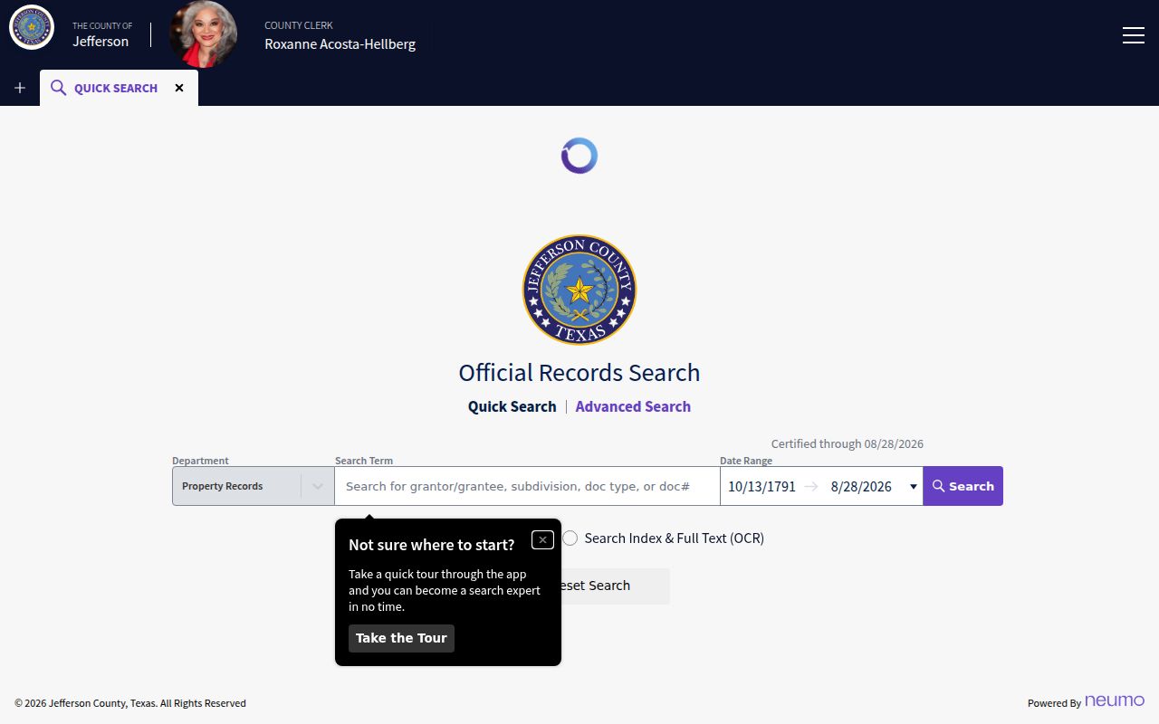
The screen illustrates why a party name alone is not enough. A dated document number and legal description let a Jefferson searcher connect a recorded transfer to the correct parcel instead of another property held by the same party.
Current Screens and Jefferson Deed Books
A current portal is not a promise of a complete historical run. The Jefferson County Clerk search page states that it is certified through August 28, 2026, but it does not state the earliest online index year. The Clerk’s 2024 annual report describes grant-funded legal-record digitization back to 1966 that continues through 2026. That work can expand access, yet it does not establish that every earlier book or image is searchable online. For a chain that stops at the screen, use the County Clerk counter, deed books and copy route, the Sam Houston Center’s 1834 to 1887 deed record and 1836 to 1888 index reels, or Tyrrell’s 1836 to 1946 index.
This Jefferson access difference is a practical research tip. Search the modern index first, but do not turn a no-hit into a conclusion about an earlier conveyance. Keep the document number, book and page, grantor, grantee, legal description, and the repository or reel citation together as the trail moves from a portal to a physical or microfilm source.
Note: The portal’s OCR can help with a typed legal description, but it can also misread names in a scanned record.
Jefferson Voter Records Along a Street
Voter records are a separate Jefferson layer, with their own access rules. The Texas Secretary of State directs individual users to the voter-information service for registration and polling-place confirmation. Jefferson County Voter Registration is part of the Tax Assessor-Collector and Voter Registrar structure, with registration locations in Beaumont, Port Arthur, and Mid-County. An individual lookup is not a tool for browsing every name on a street. A wider public voter-file request uses SOS Form 24-1, an affidavit, a deposit, and documented filters such as county or precinct.
The Jefferson County voter information page identifies the local registration offices and the state route for voter questions.

A registration field is dated evidence about the record, not a guarantee that every person connected with a Jefferson address is registered or still present there. Protected addresses and confidential participants are not ordinary public display.
Jefferson Street Directory History
Older Jefferson addresses need a different set of sources. Tyrrell Historical Library identifies Beaumont directories beginning in 1903, along with deed indexes, tax rolls, probate material, newspapers, yearbooks, and census microfilm and indexes. A reverse or criss-cross directory is an address-to-occupant arrangement when a run contains one. The exact local reverse-directory years were not verified, so check the library’s holdings rather than assuming a given year has a street section. The historical collections are particularly helpful after a deed identifies an earlier owner or when a newspaper notice supplies a dated address.
For directory collections and how to interpret their entries, use the Jefferson city directory collections. A historical occupant reference belongs beside the date and publication year. It should not be merged with a modern JCAD ownership field or a present voter record simply because the street label looks the same.
Jefferson Address Terms That Matter
Street labels are only one way Jefferson records describe a place. The terms below help preserve the link between a visible address, the parcel, and the recorded document. They also make it easier to bridge an old directory or map when a current postal format does not match. No countywide Jefferson street-renumbering year was located in the reviewed sources, so the safer historical bridge is a combination of cross streets, lot and block, subdivision, legal description, and map year.
- Parcel
- A mapped unit of land with its own property or geographic identifier in the appraisal and GIS systems.
- Situs address
- The physical location of the parcel or building, distinct from the address used for tax or appraisal mail.
- Plat
- A recorded map that connects a subdivision, lot, block, streets, and sometimes easements or access lines.
- Criss-cross directory
- An address-organized directory that can point from a historical street entry to a listed occupant or business.
Maps can add dated context. The Library of Congress holds a 1911 Beaumont Sanborn set with 107 sheets, while other local maps show landownership or later regional geography. Those sources can test street and building continuity, but the Clerk record remains the source for the recorded legal transaction.
Limits of a Jefferson Street Directory
A public property record identifies owners and legal interests, not every person who may be at an address. Non-owner occupants and household members are not maintained as one complete public index. Driver-license residence data is protected by the Driver’s Privacy Protection Act, and utility customer and delivery records are not ordinary public resident directories. Beaumont’s map data also cannot replace an official case file. A Jefferson result should say what the particular custodian recorded, with its date and field, rather than making a broader claim about a household.
Lawful use. Jefferson address records support personal, lawful research and civic curiosity. Do not use an address trail to stalk, harass, intimidate, or harm anyone.